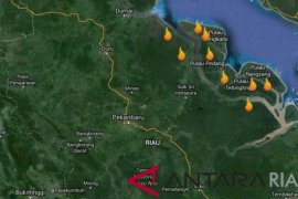
Pekanbaru, Riau, Sept 8 (ANTARA) - The US NOAA ( National Oceanic and Atmospheric Administration) satellite detected 20 hot spots in Riau Province, Sumatra Island, on Tuesday (Sept 6), an official said.
The number significantly increased from only three hot spots on the previous day (Monday, Sept 5), Yudhistira Mawaddah, an analyst of the Riau Meteorological, Climatology and Geophysics Agency (BMKG) said here on Thursday.
"The 20 hot spots spread in four districts, namely Pelalawan District with 10 hot spots, in Kuantansingingi two hot spots, and in Indragiri Hulu as well as Indragiri Hilir with four hot spots respectively,," he said.
On Sumatra Island, there were a total of 73 hot spots on Tuesday.
In addition to the 20 in Riau Province, there were also 12 hot spots in Jambi Province, two in Aceh Province, three in West Sumatra Province, three in Lampung Province, and one each in North Sumatra and Bengkulu Provinces, he said.
"Meanwhile, the most hot spots were found in South Sumatra, namely 31 hot spots," he said.
He explained the transitional condition from dry season to rainy season has triggered the hot spots in Riau as the temperature was quite high.
In Jakarta, Chief People's Welfare Minister Agung Laksono saw off the departure of the 2011 Forest Fire Operation Team to three provinces at Halim Perdanakusuma airport on Thursday.
"The forest fire operation team will be working for three months," the People's Welfare Coordinating Minister said when he saw of the departure of the team at the airport.
Minister Agung said that the team will be sent to three provinces experiencing forest and land fires namely South Sumatra, Central Kalimantan and Riau.
"Land and forest fires are main threat to Indonesia, particularly during the dry season. Forest and land fires caused different kinds of losses," the minister said.
Therefore, the government and the National Disaster Mitigation Agency are working out an integrated action plan (RAT) on the handling of haze as a result of forest and land fires.


